The First Book of the Cross-Staff
CHAPT. V. The Use of the Meridian Line.
The Meridian Line, noted with the letter M, may serve for the more easie division of the plain Sea-chart, according to Mercator's Projection. For if you shall draw parallel Meridians, each degree being half an inch distant from other, the degree of this Meridians on the Chart, from Equinictial toward the Pole: and then if through these degrees you draw straight Lines Perpendicular to the Meridians, they shall be Parallels of Latitude.
If any desire to have the degrees of his Chart larger than those which I have put on the Staff, he may take these and increase them to a double, or treble, or a decuple proportion at his pleasure.
This Meridian Line being joyned with the Line of Chords, may serve for the protraction and rsolution of such right Line Triangles as concern Latitude, Longitude, Rumb and Distance in the practice of Navigation. As may appear by this example. Suppose two places given A in the Latitude of 50 gr. D in the Latitude of 52 gr. ½, the difference of Longitude between them being 6 gr.and let it be required to know, first, what Rumb leadeth from the one place to the other; secondly, how many degrees distant they are asunder.
- I draw a right Line AE, representing the Parallel of the place from whence I depart.
- I take 6 gr. from the difference of Longitude, either out of the Line of Inches, allowing half an inch for every degree, or out of the beginning of the Meridian Line; (for the Meridian degrees differ very little from the Equinoctial degrees) and these 6 gr. I prick down in the Parallel from A to E.
- In A and E, erect two Perpendicular, AM and ED representing the Meridians of both places.
- I take the difference of the Latitude from 50 gr to 52 gr. 30 m. out of the Meridian Line, and prick it down in the Meridian from A unto M, and from E to D, and draw the right Line MD for the Paralle of the second place, and the right Line AD for the Line of distance between both places: so the Angle MAD shal give the Rumb that leadeth from one place to the other.
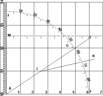
- To find the quantities of the Angle MAD, I may either make use of the Protractor, or else of a Line of Chords, and so I open my Compasses unto one of the Chords of 60 gr. and setting one foot in the Point A, with the other I describe an occult Ark of a Circle, intersecting the Meridian in F, and the Line of distance in G; then I take the Chord of FG with my Compasses, and measuring it in the same Line of Chords as before, I find it 56 gr. ½: and such is the Inclination of the Rumb to the Meridian, which is the first thing that was required.
- To find the quantity of the Line of distance AD, I take it out with my Compasses, and measuring it in the Meridian Line setting one foot beneath the lesser Latitude, and the other foot as much above the greater Latitude, I find about 4 gr. ½ intercepted between both feet: and such is the distance upon the Rumb, which is the second thing that was required.
But if this example were protracted according to the common Sea-charts, where the degrees of the Equinoctial and the Meridian are both alike; the Rumb MAD would be found to be above 67 gr. 23 m. and AB the distance upon the Rumb about 6 gr. ½
Suppose farther, that having set forth from A toward D, upon the former Rumb of 56 gr. 15 m. NEbE after the ship had run 36 Leagues, the wind changing, it ran 50 Leagues more upon the Rumb of EbN, whose inclination to the Meridian is 78 gr 45 m. And let it be required to know what Longitude and Lattitude the ship is in, by pricking down the way whereof upon the Chart.
Having drawn a blank Chart as before, with Meridian and Parallels, according to the places proposed.
- I would make an Angle MAD of 56 gr. 15m. for the Rumb of NEbE, which is done after this manner: I open my Compasses to one of the Chords of 60 gr. and setting one foot in the Point A, with the other I describe an occult Ark of a Circle, intersecting the Meridian in F: then I take 56 gr. 15 m. out of the same Line of Chords, and prick them down from F unto G: so the right Line AG shall be the Rumb of NEbE.
- I would take 36 Leagues out of the Meridian Line, extendinmg my Compasses from 50 gr. to 51,48m., or rather from as much below 50 as above 51, and prick them down upon the Rumb from A unto I; so the Point I shall represent the place where the Ship was when the wind changed. And this is the Latitude of 51 gr. 0 m. and the Longitude of 2 gr. 21 m. Eastward from the Meridian AM.
- By the same reason I may draw the Line IK for the Rumb of EbN, and prick down the distance of 50 Leagues from I onto K: so the Point K shall represent the place whither the Ship came, after the running of these 50 Leagues: and this is the Lattitude of 51 gr. 30 m. and in the Longitude of 6 gr. 16 m. Eastward from the first Meridian AM and therefore 16 m. Eastward from the second Meridian ED.
But if these two courses were to be pricked down by the common Sea-chart, the Point I would fall in the Lattitude of 51 gr. 0 m. and the Point K in the Lattitude of 51 gr. 30 m. But the Longitude of I would only be 1 gr. 30 m. and the Longitude of K only 3 gr. 57 m. more: both these do make but 5 gr. 27 m. for the difference of Longitude between the first Meridian AM, and the Point K: whereby it should seem that the Pont K is yet 33 m. Westward from the Meridian of the place to which the Shiup was bound.
Such is the difference between both these Carts.